What is VESPa and how does it work? In this interview, Maureen Doyle, project manager of VESPa – the Virtual Environment Sampling Platform, explains how the tool works and how it can help students with acquiring sampling skills.
What is the purpose of your project, VESPa?
The purpose of the project was to create an interactive online mapping tool that can be used to learn sampling techniques and I was given the opportunity to develop this tool (VESPa) by the IT Innovation Challenges team in 2017.
What is a sample?
In research terms, a sample is a selected number of individuals taken from the total population so therefore the way in which we select a sample is critical since it will determine the best action or management. Thus if the sampling phase is weak, the integrity of the entire research project is at risk.
What are the most common sampling techniques used in research?
All disciplines use some form of sampling techniques which encompass their own advantages and disadvantages and there is always some degree of sampling error so it is important to evaluate the best sampling method. For disciplines where the data needs to be analysed on site such as ecology/field biology, archaeology and geology they do this by dividing the area being studied into sub-zones or strata to give a more precise estimate of the whole population. The most common sampling methods used are: Quadrats, Line Transects or Point sampling.
Quadrats normally consist of square frames of set sizes and the species or findings are recorded within the square.
Transect lines can be made using nylon ropes or measuring tapes marked and numbered at 0.5m, or 1m intervals, and the findings are recorded along its length.
The point sampling method is a technique based on point readings taken at either systematic or random locations and used to determine species cover or density.
How can VESPa help researchers and students with sampling?
With VESPa we have replicated real-life sampling employing the key sampling methods. Ted Koterwas – head of IT and his team – designed VESPa using Google’s My Maps. VESPa allows users to import different datasets, to sample any geographical area and to analyse and compare sampling methods.
At present, VESPa has created the following datasets: Ecology, Medical Sciences, Geography, Archaeology and Geology in order to demonstrate proof of concept. Effectively, VESPa has unlimited potential.
The tool can be accessed by going to: https://vespa.itchallenge.ox.ac.uk
How exactly does VESPa work?
The main screen displays a list of the current datasets as well as the option to create a new one by importing a KML file. KML files can be created in GIS, Google My Maps or Google Earth. The new dataset can then customise for teaching or research purposes.
If you would like an admin account, please contact the IT department.

Logging on to VESPa
Once the user has selected one of the maps and it is ready to be sampled, they can select the sampling method on the bottom left corner …
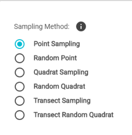
VESPa’s sampling methods
… and apply it to the map.
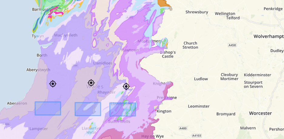
Quadrats and point samples set on the map
After sampling the different areas, the results tab (on the right-hand bottom) will show a preview of the results, which can also be downloaded as a csv file.
It is easy for students to acquire and diversify their skills in sampling techniques with VESPa.
Read the first part of the interview with Maureen to learn more about the story behind VESPa.